New research by Virginia Tech scientists shows that sections of the Chesapeake Bay are sinking at rates of nearly a quarter an inch – or 7 millimeters – a year. Up-to-date knowledge of where the ground in the Chesapeake Bay area is sinking and by how much is not included in the official planning maps that authorities use to assess the local flooding risk from rising sea levels, the researchers said.
This poses a significant challenge to present and future management efforts as it could under or overestimate flooding risk to coastal communities along the stretch of Virginia shoreline, said Manoochehr Shirzaei, an associate professor of radar remote sensing engineering and environmental security in the Department of Geoscieces, part of the Virginia Tech College of Science, and a member of the Virginia Tech National Security Institute.
The new findings from the Virginia Tech Earth Observation and Innovation Lab appear in the Journal of Geophysical Research, with scientists having measured how much the land along the Chesapeake Bay’s shoreline has sunk using interferometric imaging with synthetic aperture radar from Earth orbit to detect elevation.
The latter technique can measure year-to-year changes in local ground elevation as small as a millimeter, said Sonam Futi Sherpa, a doctoral student in the Department of Geosciences and lead author of the study.
The study uses data from 2007 to 2020. The researchers further estimated potential inundation through the 21st century coming from land elevation changes, sea level rise and storm surge.
“Although we found that most of the bay is sinking by less than 2 millimeters a year, in several areas, we discovered subsidence rates of 4 to 5 millimeters per year and more,” Sherpa said.
Chandrakantha Ojha of the Department of Earth and Environmental Sciences at the Indian Institute of Science Education and Research also contributed to the study.
The region hosts the largest naval base in the world, Naval Station Norfolk, and has a dense population of more than 1.7 million people alongside wildlife, Shirzaei said. Its attraction as a tourist destination is also among the highest in the state.
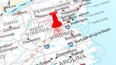
Sherpa points to Chesapeake Bay’s Hampton Roads, which includes Norfolk, Newport News and Virginia Beach, as hot spots of land subsidence occurring at a relatively high rate, exacerbating the effects of sea level rise and storm surge. Located in the bay midway between Montross and Reedville near the Potomac River, the area is subsiding because of groundwater pumping and erosion, the study found.
The researchers said such activity is typical of most areas of land subsidence. Many hot spots are sites of anthropogenic activities such as groundwater pumping causing compaction of aquifer systems, while others are places where land is lost to erosion.
The researchers said state, county and municipal administrations along the Chesapeake currently use maps prepared by the Federal Emergency Management Agency to make plans for dealing with possible flooding. These maps show areas at risk based on rising sea level projections from the Intergovernmental Panel on Climate Change.
When scientists examined different sea-level rise scenarios compounded with effect of land subsidence, they found that, for the Chesapeake Bay, by the year 2100, 282 to 373 square miles face a risk of flooding for very low to very high greenhouse gases emission scenarios. Storm surges similar to 2003’s Hurricane Isabel’s can increase the inundated area from 527 to 694 square miles from 2030-2100 while considering a very high greenhouse gas emission scenario.
“There are many estimates and models for sea-level rise, but they all fall short because they don’t take into account land elevation changes,” said Shirzaei, who is also an affiliated member of the Global Change Center, part of Virginia Tech’s Fralin Life Sciences Institute. “When formerly dry land becomes flooded, it causes saltwater contamination of surface and underground water, and it accelerates coastal erosion and wetland losses.
“The flooding hazards maps of the Chesapeake Bay area need to be updated with the measurements of land elevation changes and updated projections of sea level rise,” Shirzaei said.
Tom Allen, a professor of political science and geography at Old Dominion University, will do exactly that with the data provided by Sherpa and Shirzaei. Allen said the updated maps can be used by authorities to create effective adaptation strategies.
Sherpa said that sinking ground along the shoreline greatly magnifies the effects of sea level rise because both processes work together to worsen the situation.
“The ground goes down, sea level comes up, and flood waters go much farther inland than either change would produce by itself,” she said.
What is the long-term solution? The answers vary, Shirzaei said.
“The growing risks in coastal cities pose a major challenge, and adaptation is to be expected. However, the solution varies from place to place and must be tailored to the individual situation,” he said.
“Adaptation to relative sea level rises comprises three main categories of defense: protection, accommodation and retreat. And coastal communities can choose and pick from a long list of options, such as upgrading protection facilities, such as dams, raising lands, maintaining and restoring wetlands protection, controlling subsidence, improving flood resiliency, selective relocation of important infrastructure and installing flood warning systems.”


