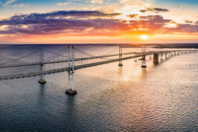
From a planned casino on the Elizabeth River to the fate of Tangier Island, a new website and interactive map will let users see how rising seas, storm surge and expanding floodplains will affect their communities, providing a visual glimpse into how a changing climate will unfold across Hampton Roads.
The Changing Coast, an interactive digital tool released today by the Southern Environmental Law Center, conveniently concentrates an array of climate data into a single interface.
The project’s goal is to show citizens and decision-makers how the coast is changing, and how proposed infrastructure projects like highways, neighborhoods, and government or industrial facilities will fare as the water keeps rising and floods get worse.
Hampton Roads is experiencing a rate of sea level rise nearly unmatched on the East Coast.
For example:
- The proposed Nimmo Parkway extension would cut through some of Virginia Beach’s most dense and intact wetlands, areas needed to absorb floodwater and buffer against rising seas.
- Rather than helping an evacuation, the Mid-Currituck Bridge could be empty and unused in a natural disaster. Now, a Category 2 hurricane could swamp the roads leading to it; and in the future with just two feet of sea level rise, those roads could be underwater on a sunny day.
- Tangier Island could be submerged now by the storm surge of a Category 1 hurricane, or in the coming years if sea level climbs just two feet.
Hampton Roads, like other East Coast regions, has experienced worsening flooding from more powerful storms, stronger hurricanes that linger longer, and the destruction of natural flood protections. This tool puts all that information into a single interface.
“This tool and the data behind it will show you where water will be in the coming years,” said Chris DeScherer, a senior attorney with the Southern Environmental Law Center. “It will also reveal how proposed subdivisions and infrastructure will fare as sea levels continue to climb. The goal is to help guide decisions for the future, and to plan smart strategies to protect what exists now.”
The Changing Coast designers incorporated about a dozen databases to show a comprehensive picture of how future flooding will affect the Hampton Roads area, along with coastal communities as far inland as Richmond and as far south as Georgia.
The states covered by the data are Virginia, North and South Carolina, Georgia and Alabama.
Support AFP


AFP