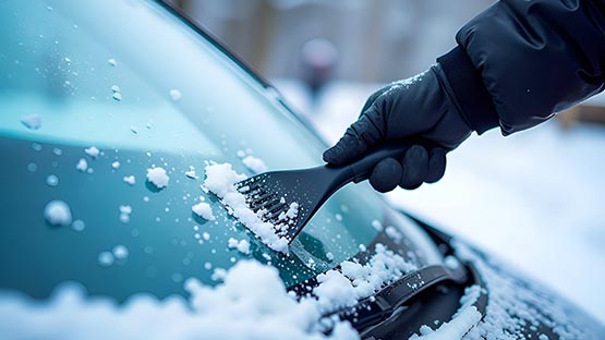
It might be time to break out the ice scraper, snow shovel and winter gear, as cold weather and a wintry mix will cause travel headaches over the next week.
The first storm will bring freezing rain and ice throughout much of Virginia starting tonight around midnight.
A winter weather advisory has been issued for Virginia and West Virginia with mixed precipitation on the way. The advisory is in effect from 1 a.m. to noon on Tuesday, according to the National Weather Service.
Precipitation is expected in the form of freezing rain. Snow and sleet accumulations up to one inch are possible with ice accumulation between one tenth of an inch and two tenths of an inch.
AccuWeather is monitoring the increasing threat for icy conditions that will make roadways and sidewalks slippery. Ice accumulation is also likely on trees and power lines.
The advisory is in effect for portions of central, northern, northwest and western Virginia and eastern West Virginia.
In Virginia, the counties included in the advisory are:
- Albemarle
- Augusta
- Clarke
- Culpeper
- Fauquier
- Frederick
- Greene
- Highland
- Loudoun
- Madison
- Nelson
- Orange
- Page
- Rappahannock
- Rockingham
- Shenandoah
- Warren
Those who have not completed winterizing their homes and water lines or had their furnaces checked and heating oil or propane ordered may want to do so as soon as possible.
VDOT: Slick spots possible during Tuesday morning commute
The Virginia Department of Transportation is preparing to plow and treat roadways as needed throughout the Staunton district.
According to VDOT, ice accumulation is forecast in the central and southern parts of the region including the counties of Alleghany, Rockbridge, Bath, Highland and Augusta. Snow is expected in the northern Shenandoah Valley.
Slick spots are possible during the morning commute, especially in higher elevations and on elevated surfaces such as bridges and overpasses. VDOT advises motorists to postpone travel if possible until temperatures rise and conditions improve Tuesday afternoon.
VDOT’s first priority for treating roadways is the interstate highway system, followed by primary roads (routes numbered 1 to 599) and major secondary roads (numbered 600 and up) with key infrastructure or high-traffic volumes. Other secondary roads and subdivision streets are plowed or treated when higher-priority routes are completed and resources are available.
The Staunton district includes Frederick, Shenandoah, Clarke, Warren, Page, Rockingham, Augusta, Highland, Rockbridge, Alleghany and Bath counties.
The latest road conditions are available by calling 511.
AccuWeather: Cold blast ahead, snow possible first of week
Another potential is brewing for a wintry mix on Friday afternoon. However, the extent of the snow, ice and rain will depend on how it interacts with a blast of Arctic air.
Temperatures will be 15 to 20 degrees below normal, AccuWeather meteorologists say.
A winter storm with accumulating snow is possible next week on Monday or Tuesday in the Shenandoah Valley. Keep an eye on the forecast for the latest conditions.
Virginia State Police: Tips for driving in bad weather
Virginia State Police is encouraging drivers to pay attention to messaging from the Virginia Department of Transportation due to the potential of freezing rain tonight into tomorrow morning.
VSP offers these tips to reduce the potential for crashes on the road:
- Use headlights. Increasing your visibility helps you to avoid slick and dangerous spots on the road, as well as helps other drivers see you better.
- Slow your speed. Though State Police works closely with VDOT to identify problem areas on Virginia’s highways during a winter storm, drivers still must drive for conditions. Slowing your speed gives you more time to safely react and avoid a crash. Drive your vehicle based on your ability to properly maintain control of your vehicle.
- Don’t tailgate. You need increased stopping distance on slick road surfaces. Give yourself more space between vehicles traveling ahead of you to avoid rear end collisions.
- Buckle up. Most crashes that occur during winter weather are caused by vehicles sliding into guardrails, off the road or other vehicles. Wearing your seat belt protects you from being thrown around the inside of your vehicle and suffering serious injury in a crash.
- Check your vehicle. Make sure your vehicle is in good working order for the conditions. Fill up the tank in advance. Check windshield wipers, windshield wiper fluid, tire tread, battery life, etc.
- Don’t leave home without a window scraper, blanket, bottled water, snack, cell phone charger and flashlight.
Waynesboro: Best ways to track snow removal
The City of Waynesboro is ready for potential snowfall. Crews have pretreated known trouble spots with brine including hills, bridges, intersections and major and secondary roads. You may notice the white lines on the pavement where they were pretreated, according to an update from the city.
The city is reminding residents of the best ways to track snow removal:
- Use the interactive snow removal progress map online.
- Check for updates on the Public Works social media page.
- Call the snow removal hotline at (540) 932-8240 or contact public works operations at (540) 942-6743 or email [email protected]
Related story
Support AFP


Crystal Graham