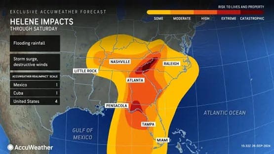
Strong winds and heavy rain may lead to deadly flooding in some parts of Virginia due to the remnants of Hurricane Helene. In some areas, Virginians may see eight inches or more of rain. Isolated tornadoes are also possible, according to an AccuWeather senior meteorologist.
Steady and heavy bands of rain from Helene will spread north across the state tomorrow and then shift north of the state tomorrow night.
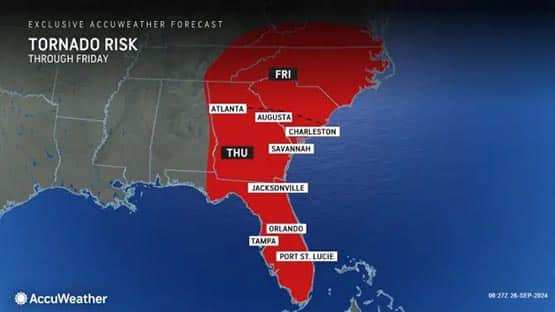
There can be isolated tornadoes across the southern third of the state tomorrow as rain bands cross the state.
Helene may bring additional rain to Virginia early next week when the storm system heads east.
- Follow AccuWeather coverage online.
- Follow local impact on Augusta Free Press.
Southwest Virginia to get hammered
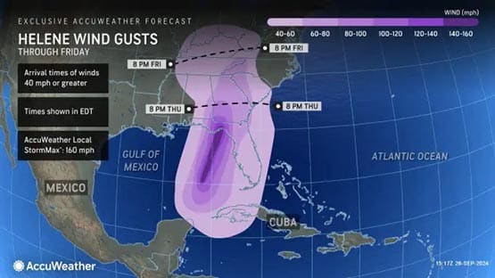
“Strong winds of 40-70 mph with higher guests over the ridges from Helene will reach southwest Virginia late tonight and continue into tomorrow morning,” said Bob Smerbeck, a certified consulting meteorologist with AccuWeather.
Power outages are possible in southwest Virginia. The storm should weaken tomorrow afternoon in the region.
Central Virginia and Shenandoah Valley conditions likely moderate
Moderate winds gusting 35 to 45 mph will impact southern and central Virginia tomorrow, including Waynesboro, especially over the ridges, Smerbeck said. Power outages should be isolated.
“Rain will continue the rest of today and tonight over western Virginia and some will be moderate to heavy over southwest Virginia, but mainly to the west of Roanoke, so flooding will continue to be a problem over those areas,” said Smerbeck. “There will mostly be light rain in Waynesboro/Charlottesville areas through tonight so any flooding issues should not get worse.”
Rain predictions
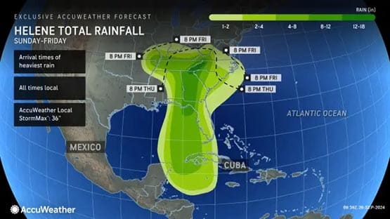
The heaviest rain tomorrow will occur once again over the southwest part of the state with three to eight inches falling and resulting in widespread and deadly flooding, especially to the west of Roanoke and along the Blue Ridge, he said. The higher amounts will mostly likely over the ridges.
There should be one to two inches of rain tomorrow over southern and central Virginia including the Waynesboro area, where some minor flooding can occur.
Farther north and east, rainfall from Helene should not exceed one inch.
Helene’s path
Helene will make landfall likely as a major Category Four hurricane near Apalachee Bay, Fla., this evening and then track to the north and weaken across western Georgia tonight.
Helene will continue to weaken and track to northwest into central Tennessee and away from Virginia during the day tomorrow.
“Helene will stall over western Tennessee on Saturday and lose a lot of its punch,” Smerbeck said.
Helene may hit Virginia twice
Eventually, Smerbeck said, Helene will head to the east early next week and could cause additional showers over the Waynesboro area.
There should only be light rain showers across the state on Saturday but flooding from runoff will continue, especially over the southwest part of the state along the Blue Ridge.
AccuWeather forecast maps
Related stories
Search “weather” on Augusta Free Press.
- Developing: Region prepares for possibility of heavy rain due to Hurricane Helene
- National Weather Service issues flood warning for Waynesboro, Augusta, Rockingham
- State of Emergency: Western Virginia could experience significant rainfall from Helene
- Virginia disaster response team activated by FEMA; en route to Florida to assist with Helene
- Meteorologist: ‘Virginia can certainly get dumped on by Helene’

