A flood watch is in effect from 3 p.m. this afternoon through 2 a.m. Saturday morning for portions of Virginia and West Virginia.
Slow-moving showers and thunderstorms are possible this afternoon and evening. One to three inches of rain are possible with localized amounts up to four inches.
“It looks like any time after 3 p.m. is fair game for heavy showers in the flood watch area which is generally from around Route 29 on west,” said Thomas Kines, a senior meteorologist with AccuWeather. “There is not a flood watch in effect for the eastern part of the state, although I certainly wouldn’t rule out heavy rain there overnight.”
Kines said hail, damaging wind gusts and tornados seem unlikely with this line of storms.
Those living in areas prone to flooding should be prepared and monitor forecasts.
“Not everyone in the flood watch area will receive flooding rains,” Kines said. “However, some areas can certainly receive between 1 and 3 inches of rain which would at the very least cause poor drainage flooding and possibly stream and river flooding.”
According to the alert:
- Excessive runoff may result in flooding of rivers, creeks, streams and other low-lying and flood-prone locations
- Creeks and streams may rise out of their banks
- Flooding may occur in poor drainage and urban areas
- Low-water crossings may be flooded
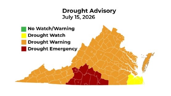
The flood watch includes:
- Albemarle
- Augusta
- Central Virginia Blue Ridge
- Culpeper
- Eastern Highland
- Greene
- Madison
- Nelson
- Northern Virginia Blue Ridge
- Orange
- Page
- Rappahannock
- Rockingham
- Shenandoah
- Warren
The flood watch also includes eastern West Virginia including Eastern Pendleton and Hardy.
Support AFP


Crystal Graham