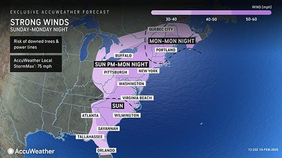
Wind gusts up to 60 miles per hour are possible into Monday morning as the weekend storm departs, according to Tom Kines, an AccuWeather senior meteorologist.
Damaging winds could blow down trees and power lines, and widespread power outages are possible. Travel could also be difficult for high-profile vehicles.
The strongest wind gusts are expected Sunday afternoon, according to the National Weather Service.
The high wind watch area includes most of the state: Augusta, Rockingham, Shenandoah, Frederick, Highland, Page, Warren, Clarke, Rappahannock, Fairfax, Arlington, northern Fauquier, Loudoun and Prince William counties. It also includes Northern Virginia, Washington, D.C., Hampton Roads, Richmond and surrounding areas.
In preparation, Virginians should fasten loose objects or shelter objects in a safe location prior to the onset of winds.
Near the Chesapeake Bay, a Gale warning is in effect until 10 a.m. on Monday as waves of three to five feet are expected. The affected areas include Little Creek, Cape Henry and the Chesapeake Bay Bridge Tunnel. Strong winds will cause hazardous waves which could capsize or damage vessels and reduce visibility, according to the National Weather Service.
Winter weather advisory issued for western Virginia
A winter weather advisory is in effect until 7 p.m. tonight with mixed precipitation, including ice and snow, possible in western Virginia.
Precipitation will start as snow or sleet before changing over to freezing rain. The most impacted areas will be elevations of 1,500 feet or more.
Afton Mountain’s elevation is approximately 1,900 feet. Waynesboro sits at approximately 1,400 feet in elevation.
The National Weather Service expects slippery road conditions, especially on bridges and overpasses.
Precipitation should change over to rain by this evening in most locations.
Flood watch through Sunday afternoon
The flood watch issued in the Shenandoah Valley now includes both Augusta and Highland counties and runs from 6 p.m. tonight through Sunday afternoon.
One to two inches of rain is expected. Due to saturated ground and the melting of snow, flooding is possible.
Similar rainfall amounts are expected in Alleghany, Amherst, Bath, Bland, Botetourt, Carroll, Craig, Floyd, Giles, Grayson, Montgomery, Pulaski, Roanoke, Rockbridge, Smyth, Tazewell and Wythe counties. The flood watch in these regions runs until 7 p.m. on Sunday.
Related stories
- Massive storm developing that could bring up to a foot of snow to Virginia this week
- Weekend update: Freezing rain, flooding possible in portions of Virginia
Support AFP


Crystal Graham