Update: 8:34 p.m.
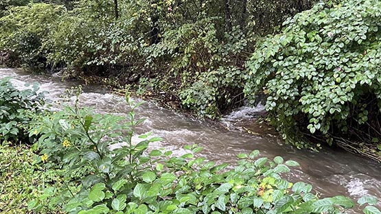
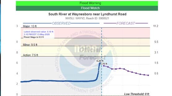
Waynesboro update from Gary Critzer: “Currently the South River is at 6.6 feet. It is expected to remain below flood stage. We have some water in the streets in low lying areas like A Street and Kirby Street. Otherwise, we are currently doing okay. There has been a fair amount of activity in the county.”
We have an inquiry out to Augusta County for more information.
Life-threatening flash flooding is possible in flood-prone areas in Albemarle, Augusta and Nelson counties through 7:45 p.m. tonight.
The National Weather Service in Sterling has issued a flash flood warning for northeastern Albemarle County, northeastern Nelson County and southeastern Augusta County.
The warned area includes Crozet, Crimora, Wintergreen, Afton, Nellysford, Greenwood, Yancey Mills, Batesville and Greenfield.
The warning includes the following flood-prone roads: Route 614 along Moorman’s River and Highway 635 at the North Fork of the Rockfish River.
Doppler radar indicates thunderstorms are producing heavy rain across the warned area. Between 0.5 and 1 inch of rain has fallen. The expected rainfall rate is 1 to 2.5 inches in one hour. Additional rainfall amounts of 2 to 3 inches are possible in the warned area.
Flash flooding is ongoing or expected to begin shortly.
Flood warning issued for Waynesboro, Augusta County
A flood warning has also been issued for a wider area and is effective until 10:30 p.m. this evening. The warning includes the City of Waynesboro and Augusta County including Stuarts Draft, Grottoes, Sherando, Verona, Lyndhurst, Fishersville, Weyers Cave and Greenville.
Additional rainfall amounts of 1 to 3 inches are possible in these areas.
For now, the current river forecast in Waynesboro is below flood stage, according to Gary Critzer, director of the Waynesboro Department of Emergency Management and EMS.
Critzer said he just wrapped up a conversation with the National Weather Service in Sterling.
“We do anticipate some flooding of small streams and creeks if they aren’t already,” he said. “We will need to watch our south closely for any event of a significant cell of heavy rain that could cause us issues.
“Currently things are looking in our favor,” Critzer said.
AccuWeather Senior Meteorologist Tom Kines told AFP on Monday that the Shenandoah Valley and the mountains had the highest risk for flooding with these storms.
Flood watch in effect for other areas in Virginia
A flood watch is in effect until 2 a.m. Wednesday for all of the above areas plus Highland, Greene, Madison, Rappahannock, Rockingham, Shenandoah and Warren counties.
Excessive runoff may result in the flooding of creeks, streams and other low-lying and flood-prone locations. Low-water crossings may be flooded.
Most flood deaths occur in vehicles. Turn around if you encounter a flooded roadway.
For more information on flood safety, visit www.weather.gov/safety/flood
Related stories
- In the crosshairs: Shenandoah Valley, mountains at ‘highest risk’ of flooding
- Waynesboro: 40 years of work mitigated flooding damage from Helene
- Waynesboro: ‘Some damage, but not catastrophic,’ as Helene passes through
- Aftermath of Debby: Downed trees, power outages left in path of tropical storm
Support AFP


Crystal Graham