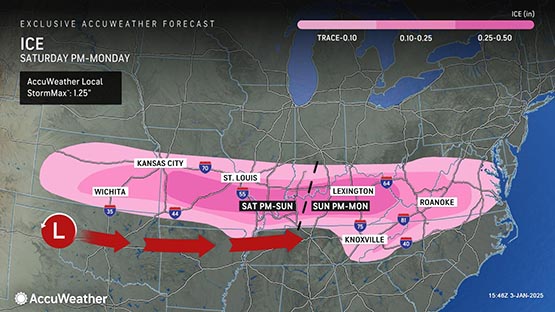
 The potential for a big snowstorm has been the talk of the town this week, but one weather expert said that freezing rain and ice are the bigger concern for the region.
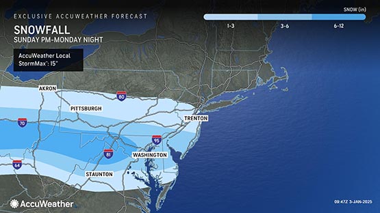
AccuWeather Senior Meteorologist Thomas Kines said that Waynesboro should receive one to three inches of snow and ice on Sunday and Monday. He expects more accumulation to the north of Waynesboro and less to the south.
“Snow arrives Sunday night and then mixes with and changes to sleet and freezing rain and ends Monday evening,” Kines told AFP.
“Travelling on Monday, especially the first half of the day, will be an adventure,” he said.
With the likelihood of freezing rain, there is also the concern for power outages.
Virginia Governor Glenn Youngkin put out a statement Thursday “urging all Virginians to monitor weather forecasts, prepare for potential impacts and heed warnings.”
Shenandoah National Park announced it will close Skyline Drive at 5 p.m. on Saturday due to the expected snow.
A cold weather pattern is ahead for the region, Kines said. While temperatures in the 40s are typical this time of year, highs will range from 27 to 35 degrees over the next seven to 10 days. Lows will be in the teens.
The long-range AccuWeather forecast shows the next chance of snow or a wintry mix occurring Jan. 14-16.
Related stories on weather, snowstorm
Go to our “weather” archives for the latest storm information.
- Weather expert: First major snowstorm of the season possible in Virginia
- Dreaming of a white Christmas in Virginia? Expert gives us his predictions for snow
- Virginia forecasters disagree on predictions for snowfall this winter, expert explains why
- Bundle up, Virginia: Prepare yourself for period of colder temperatures, possible snow
- A winter wonderland? Expert weighs in on snowfall chances in Virginia
Support AFP


Crystal Graham