 States of emergency have been declared and millions are facing evacuation orders from Georgia to North Carolina as dangerous Hurricane Dorian, a Category 4 storm, continues to grow in size.
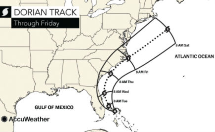
After paralleling the Florida Atlantic coast during the first part of this week, Dorian is forecast to turn northeastward and parallel the Carolina coast with battering winds, pounding waves and torrential rain later this week.
AccuWeather meteorologists continue to believe that the center of Dorian will remain east of Florida, but have concerns for a direct strike on the Carolinas and significant impact is in store for coastal areas even if landfall is avoided.
“Even though Dorian is forecast to gradually lose intensity near the eye, the hurricane will gradually grow in girth in the coming days,” according to AccuWeather Hurricane Expert Dan Kottlowski. “This means that the areal extent of hurricane and tropical storm conditions will increase as Dorian encounters the United States.”
This trend began over the Bahamas this past weekend and will continue until the storm moves over the cold waters of the North Atlantic during the upcoming weekend. Dorian will remain an ordeal for residents, visitors, officials, shipping and cruise interests much of this week along the Atlantic seaboard.
“People are urged to heed evacuation orders when issued,” Kottlowski said.
Preparations to protect property need to be completed as soon as possible. Small craft should be secured in port. Cruise and shipping interests should avoid the path of Dorian.
Support AFP


AFP