Virginia Tech’s Center for Geospatial Information Technology has been working to improve informational databases across service lines of the Virginia Department of Veterans Services.
The work of the center, which is based in the College of Natural Resources and Environment, will help 15,000 veterans access educational, employment, and support resources across Virginia.
The Center for Geospatial Information Technology’s involvement with the effort came at the request of Virginia Tech’s Institute for Policy and Governance, which had supported a database serving the Virginia Veterans and Family Support Program, formerly the Virginia Wounded Warrior Program, for six years.
The institute, affiliated with the College of Architecture and Urban Studies, proposed enhancing and expanding the existing database management system to serve multiple service lines within the Department of Veterans Services and turned to the center to leverage its breadth of programming capacity and expertise. Management of the project transitioned to the center in July 2016.
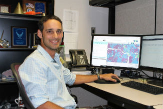
“The Institute for Policy and Governance laid the foundation for us to build a new database that will be more reactive to the needs of the various service lines of the Virginia Department of Veterans Services,” said Center Operations Officer Brandon Herndon, who served as the lead on the project.
The Center for Geospatial Information Technology developed a new database for both the Virginia Veterans and Family Support Program and Veterans Education, Transition, and Employment, a directorate of five organizations that helps veterans access educational and employment opportunities. The center worked to determine the specific needs of each organization and to facilitate communications between veterans and their dependents and schools, businesses, hospitals, and other service providers.
The new system went live in February 2018, with all organizations full transitioned by June 2018.
Herndon’s experience as a 10-year veteran of the U.S. Air Force was an asset throughout the process. “As a veteran, I was able to be an engaged collaborator, recognizing the different needs of each organization. And because I was familiar with the terms and data that these organizations were working with, I could ensure we developed a program that best suited their needs.”
A central challenge to the project was to create a program that would be adaptable to the specific needs of each organization. To meet this goal, the center utilized a third-party software package called Zoho CRM.
“This software is like a box of Legos,” Herndon explained. “It allows us to make rapid implementation of workflows, ideas, and reporting requirements.”
An additional challenge was merging a wide range data from several different sources and databases. Project Associate Javier Ramírez was tasked with creating a process to import thousands of data points into a single system, thus reducing data duplication. Each organization required custom design to meet its needs as well as custom programming to process and import its historical data into the new system.
Owing to the flexibility and interconnectedness of the new database management system, Herndon feels that the implementation will free up time for staff members, allowing them to be more responsive to the veterans they work with.
The work of the center was praised by the Virginia Department of Veterans Services. Commissioner John Newby said, “The client management system built by the Center for Geospatial Information Technology increases our ability to coordinate across Veterans Education, Transition, and Employment, and Virginia Veterans and Family Support programs, enabling more streamlined communications and better tracking so we can consistently improve service delivery.”
Matt Leslie, assistant director of the Virginia Veterans and Family Support Program, echoed this praise. “The user-friendly system has enhanced the ability of our staff to spend more time working directly with clients while tracking progress of connecting clients to the best services available. The system provides us with more tools to drill down and assess the quality of the services we provide.”
As the center’s role transitions from development to maintenance under a new contract with the Virginia Department of Veterans Services, Herndon is looking forward to expanding the center’s contributions to Virginia veterans.
“Since we’re a geospatial office, we’re hoping that the next step will be to use the data to create additional, public-facing tools that veterans can use. For example, if veterans are looking for educational opportunities, we can use geospatial data points to help them find colleges, trade schools, or certificate programs nearby that are eligible to receive GI Bill funding.”
Peter Sforza, director of the Center for Geospatial Information Technology, added: “Our applied research focus is to develop information infrastructure and analytics to deliver data-driven results by incorporating the best available science and technical approaches for any particular problem. We’re excited to help build a solid foundation of information and technology that further enables the Virginia Department of Veterans Services to better connect the veterans and families they serve to the wealth of resources available to them.”
Support AFP


AFP