In Virginia, the watch includes the cities of Harrisonburg, Staunton and Waynesboro.
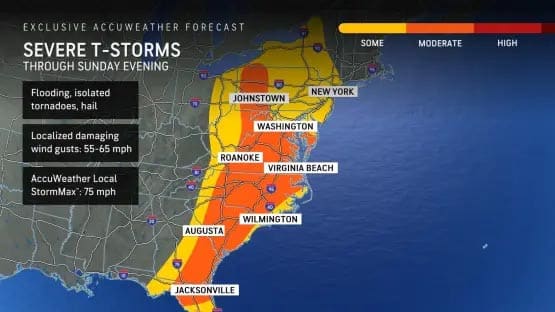
The storm that brought blizzard conditions to the northern Plains and flash flooding to the Tennessee Valley, is bringing severe weather to East Coast states today.
The severe thunderstorm threat includes over 10 states as it progresses eastward through Sunday night. There will be the risk of power outages and major travel disruptions, and property owners and road crews should be prepared for downed trees and flash flooding.
There were multiple tornado reports across Missouri, Illinois, Arkansas, Mississippi, Louisiana and Alabama with at least 35 fatalities reported as a result of the devastating storms from Friday to early Sunday morning, according to AccuWeather.
Tornado watch: Western Virginia
- Augusta County
- Harrisonburg
- Highland County
- Rockingham County
- Staunton
- Waynesboro
Tornado watch: Northwest Virginia
- Clarke County
- Frederick County
- Page County
- Shenandoah County
- Warren County
- Winchester
Tornado watch: West Virginia
- Berkeley
- Grant County
- Hampshire County
- Hardy County
- Jefferson
- Mineral
- Morgan
- Pendleton County
The watch area also includes: Berryville, Charles Town, Cumberland, Fort Ashby, Franklin, Front Royal, Frostburg, Grantsville, Hagerstown, Keyser, Luray, Martinsburg, Monterey, Moorefield, Mountain Lake Park, Oakland, Paw Paw, Petersburg, Romney, Shenandoah, Shepherdstown, Stanley, Strasburg, Winchester and Woodstock.
Isolated wind gusts of 40 to 50 mph are possible especially along and just west to northwest of higher terrain.
Tree limbs could be blown down and power outages are possible due to wind.
Winds this strong can make driving difficult especially for high-profile vehicles.
The severe weather may lead to flight delays and cancellations at the major airport hubs from Charlotte to Washington, D.C., Philadelphia and New York City.
The NWS also recommends securing loose objects.
Support AFP


Crystal Graham