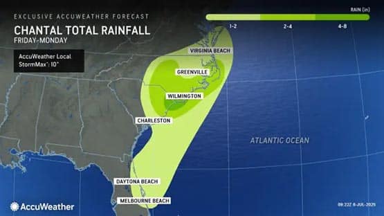
Tropical Storm Chantal could bring heavy rain, gusty winds and rough surf to Virginia tonight, according to an AccuWeather meteorologist.
The storm made landfall early Sunday morning at 4 a.m. near Litchfield Beach, S.C.
“Chantal has moved inland, and this morning is located in southeastern North Carolina, causing heavy rain and gusty winds in that region,” said Thomas Kines, a senior meteorologist and director of forecaster scheduling for AccuWeather.
“We don’t think Chantal will have a major effect on the state [of Virginia], but it can bring 1-2 inches of rain to areas east of the Shenandoah Valley, mainly from the I-95 corridor to the coast, which can cause some flooding of poor drainage areas,” he said.
Kines said they don’t think wind will be a major problem but there could be gusts up to 40 mph along the southern coast and rough surf tonight and Monday.
“There is still the risk of what is left of Chantal racks farther west and north into Virginia and if this happens, heavy rain can spill into the Shenandoah Valley,” he said.
Rain from Chantal will affect the state starting later today and continuing into Monday. Moisture from Chantal should move out over the ocean Monday night and Tuesday.
Chantal is the third tropical storm of the 2025 Atlantic hurricane season, following Andrea and Barry from June. The Atlantic hurricane season officially runs from June 1 to November 30.
Unsettled weather predicted this week in Virginia
An approaching cold front moving toward Virginia could lead to heavy rain and damaging wind gusts this week.
“An approaching cold front will move toward the state Tuesday and take its good old time crossing the state,” Kines said. “This could lead to a couple or few days of unsettled weather, resulting in the daily occurrence of a thunderstorm or two Tuesday through Thursday.
“Since there will be a rather humid air place, any of these thunderstorms can bring heavy rain. Damaging wind gusts are also a concern.”
Related stories
- Did the DOGE layoffs at the National Weather Service just kill a bunch of people?
- Myrtle Beach: Search continues for 21-year-old man missing since Wednesday
- Staunton: City looks to address flood risks, public asked to weigh in
Support AFP


Crystal Graham