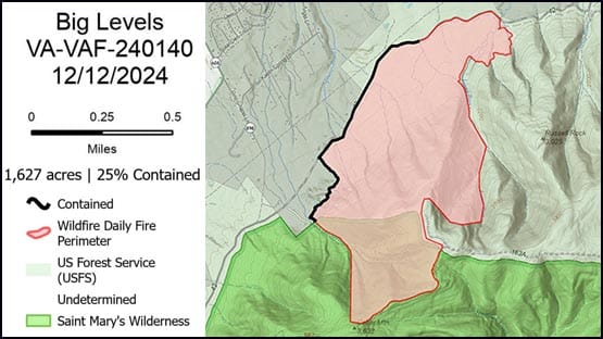
The total acres impacted by the fire has been revised to 1,627 after personnel used GPS and a mapping system to get a better estimate.
Winds today will gust up to 30 mph, and colder temperatures will set out allowing finer fuels to begin to dry out again.
Fire personnel are monitoring the area for any lingering hot spots that may threaten the containment line. The perimeter will be protected to watch for any embers jumping the line.
A helicopter will be available to support efforts as needed.
A drone is in operation over the fire area searching for hot spots.
Closures remain implemented in the fire area.
Closures due to Big Levels fire
The following areas are temporarily closed to all public use due to the Big Levels fire to allow for public and firefighter safety:
- Cold Springs trail (FT#524)
- Cellar Mountain trail (FT#587)
- Bald Mountain Jeep trail (FSR#162)
- Bald Mountain Spur Road (FSR#162A)
- Saint Mary’s trail (FT#500)
- Saint Mary’s Gorge trail (FT#500B)
The national forest system lands north of the Saint Mary’s Trail (#500) and within the area bounded by the Bald Mountain Jeep Trail (FSR#162) and the Coal Road (FSR#42) are also closed.
More information
For further information, refer to the GWJNF website, follow on Facebook or contact the Glenwood and Pedlar Ranger District at 540-291-2188.
Support AFP


Crystal Graham