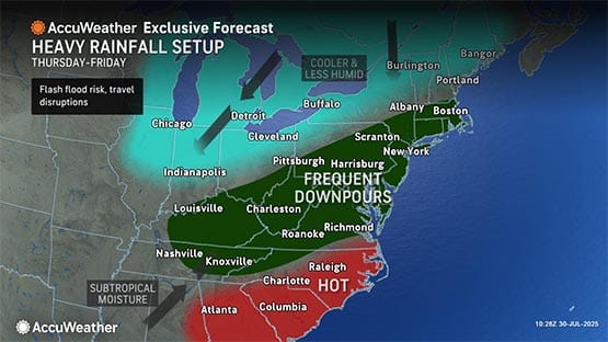
AccuWeather Senior Meteorologist Tom Kines said multiple thunderstorms are predicted with the biggest threat for flash flooding across northern and eastern Virginia in the afternoon or evening, likely north and east of U.S. Route 33.
The highest risk is in areas that are close to Interstate 66 in the D.C. area and along the Interstate 95 corridor from D.C. to Richmond.
“It looks like it could be a rough evening commute for those folks,” Kines said.
The D.C. area would need about two and half inches of rain over a three-hour period to cause flooding along creeks and rivers.
“It would not be surprising if parts of the D.C. area had more than four inches of rain in a three-hour period,” Kines said.
Those who are near creeks and rivers should have an evacuation plan in place.
While NOVA and D.C. may get the brunt of the dangerous weather, there will be thunderstorms across the rest of the state bringing one to two inches of rain.
However, Kines said, most of the thunderstorms will be east of the Shenandoah Valley.
In the Shenandoah Valley, it would take one-and-a-half to two-and-a-half inches of rain over a three-hour period to cause flooding of streams and rivers.
A dramatic cooldown with lower humidity will bring relief to the region after a long stretch of scorching summer heat.
“The front will push south of the area Friday, and lower humidity and sunshine will return over the weekend,” Kines said. “There should be a noticeable difference in how it feels from Thursday to Saturday.”
Related stories
- Emergency visits up for heat-related illness in Virginia; one fatality this summer
- Virginia: You aren’t crazy, this summer is hotter than normal
- Gov. Youngkin’s wife, family had to be rescued during Texas flooding
Support AFP


Crystal Graham