The first Atlantic hurricane of the season could bring flash flooding and tornadic activity to the Mid-Atlantic, including Virginia, on Sunday.
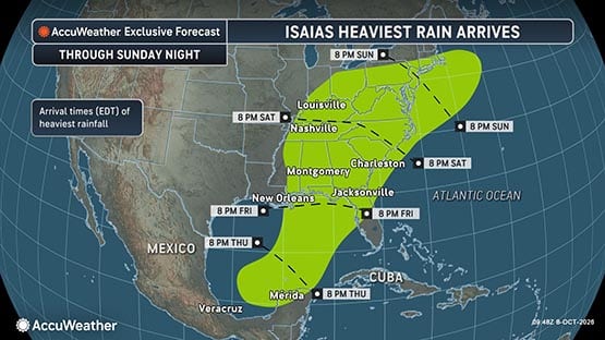
Hurricane Isaias is expected to strengthen into a Category 2 hurricane before making landfall along the central Gulf Coast Friday night, according to AccuWeather hurricane experts.
Experts are tracking the potential for heavy rainfall, flash flooding and mudslides. Torrential downpours could overwhelm some streams and creeks, flooding roads and low-lying communities. Gusty winds could also knock down trees and power lines, causing outages and travel disruptions.
A tornado threat is possible across southern Virginia, the Carolinas, eastern Tennessee and southeastern Kentucky on Sunday.
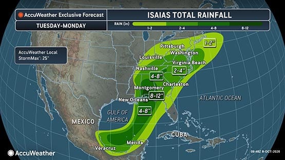
Virginia could see up to 4″ of rain
In Virginia, Saturday night and Sunday will be the wettest part of the weekend, according to AccuWeather senior meteorologist Thomas Kines.
“Rain will move into the southwest part of the state in the afternoon and rest of the state Saturday evening or early Saturday night, and continue through Sunday,” Kines said.
“Any place in the state is fair game for two to four inches of rain.”
The mountains west of the Shenandoah Valley will receive four to eight inches of rain, Kines said.
“Rain of that magnitude can certainly cause flooding of poor drainage areas and those places that received more than three inches might have to deal with the flooding of streams and creeks.
“For the most part, wind will not be a big deal although there could be a time on Sunday when winds in the southeastern part of the state and the highest elevations in the Appalachians can gust between 30 and 45 miles per hour.”
Follow the Virginia Department of Emergency Management and Virginia Governor Abigail Spanberger’s office for the latest developments.
Impact on events in Waynesboro, Charlottesville
The Virginia Fall Foliage Festival in Waynesboro is scheduled for this weekend, Oct. 10-11, in Downtown Waynesboro.
“Saturday is definitely the day to go to the fall festival,” Kines said. “Rain gear will be needed on Sunday.”
Waynesboro Department of Emergency Management and EMS Director Gary Critzer told AFP that the city is monitoring the storm and its track.
“While the ground is dry, any storm that produces heavy rains over a short period can cause flash flooding, and any prolonged heavy rain could potentially create river impacts for us,” Critzer said. “Additionally, a deviation in the track of the storm could change those impacts.”
The city is collaborating with the weather service office and Virginia Department of Emergency Management partners to “keep a close eye on the storm,” according to Critzer.
“Soil that is dry can’t absorb torrential rainfall as well as it loses its porous state, and there is runoff that can impact both flash flooding and river levels depending on the intensity of the precipitation.”
University of Virginia football fans may want to pack a poncho for the game on Saturday night as the impact of Isaias may come into play in the second half of the game. UVA plays Syracuse starting at 7:30 p.m. at Scott Stadium in Charlottesville.
“It’s going to be a close call with the arrival of the rain,” Kines said. “Certainly, there is a better chance of rain in the second half than the first. Afternoon temperatures will be in the lower 70s with dry weather for the tailgaters.”
Mudslides, road washouts possible in Appalachia
Steep terrain and saturated hillsides could increase the risk of mudslides and road washouts across the Appalachians.
“For communities across Appalachia still recovering from Hurricane Helene, the threat of another tropical system bringing heavy rain is understandably concerning,” said AccuWeather expert meteorologist Dan Pydynowski. “Isaias is expected to move faster than Helene did in 2024, which should limit the duration and extent of flooding. But it doesn’t take a repeat of Helene to cause dangerous flash flooding, mudslides and washed-out roads in these mountain communities.”
Support AFP



 Share

Crystal Graham