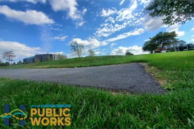
Several months ago, Harrisonburg Public Works asked the community to help come up with a name for The Friendly City’s newest shared-use path – a trail that will connect Harrisonburg High School and Bluestone Elementary to the Sunset Heights neighborhood and to Thomas Harrison Middle School and Westover Park. Construction on the trail began this spring.
Now, residents can make their mark on the city by voting for their favorite name and helping pick the winner from among the numerous unique options suggested by the community.
Voting will remain open through Sunday, Oct. 24. The poll is available in English, Spanish and Arabic at:
- www.harrisonburgva.gov/garbers-church-road-sup
- www.facebook.com/harrisonburgpublicworks
“We want everyone to have the opportunity to vote for their favorite name for this trail that will be used for generations,” Harrisonburg Director of Public Works Tom Hartman said.
Voting will be compiled once the poll closes, with names that receive the most votes being presented to City Council for the final naming decision in November.
The path, a grant-funded project through the VDOT Revenue Sharing program and the Recreational Trails Program, is part of the city’s ongoing efforts to increase connectivity in Harrisonburg and help the community enjoy the area’s abundance of outdoor recreation opportunities.
The trail will begin at the Southwest side of Bluestone Elementary and go through the back of the driving range at Heritage Oaks Golf Course. It will run along holes #1, #16 and #17 of Heritage Oaks then continue into Hillandale Park, through Wyndham Woods subdivision and on to Thomas Harrison Middle School and continue to Westover Park.
The path will be a paved trail, 10-feet wide travelling through a mix of mature and semi-mature hardwood trees and open areas.
No impacts to wetlands or waters of the United States are anticipated as part of the project. The path will be about 2.25 miles long when complete and will include some on-road sections (indicated in blue on the map above).
Harrisonburg Public Works expects the path to be complete and open for walking, jogging and bicycling by the end of the year.
Support AFP


Chris Graham